


By Professor Robert Fleming
Only a few island groups on our planet have remained mostly free of human impact and with good fortune, a portion of the Tierra del Fuego Archipelago, below the Beagle Channel, is one of these. Here lies the small (244km2/94mi2) Cape Horn National Park, which encompasses both shallow marine habitats along with the island groups of Wollaston and Hermite. Cape Horn Island itself is a miniscule part of the reserve.
Some of the islands below the Beagle Channel are treeless andexhibit tundra formations as well as alpine habitats, these often intermixed with freshwater ecosystems such as peat bogs that are repleat with species of Sphagnummosses. Indeed, the whole region is a bryophyte hotspot, especially well known for its great diversity of cold-adapted liverworts and mosses.
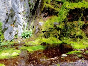
Shaded areas on islands west of the Darwin range are conducive to fern and moss growth.
In addition, other islands in the region are partly covered with a mixture of southern evergreen forests or subpolar deciduous forests. A main component of the former is the southern beech Nothfagus betuloides, and the white-flowered Drimys winteri (in the Winteraceae family). While the deciduous forests are mostly composed of the southern beeches, Nothofagus pumilioand N. antarctica.

Boardwalk in a Lenga forest (Nothofagus pumilio).

Pia Glacier with Southern Beech.
Besides land formations, the extensive, shallow marine habitat fosters ‘forests’ of giant kelp, Macrocystispyrifera,with understory belts of brown Lessenoss eaweed. This area, along with the Diego Ramirez islands to the southwest are some of most intact sub-Antarctic marine ecosystems in the world.
The underwater world here was poorly known until a recent survey by scuba diving scientists added immensely to our understanding of what lies beneath the ocean’s surface. As I have no diving experience in waters this far south, the following summary of life below the sea’s surface is taken from their report (see Marine biodiversity at the end of the world: Cape Horn and Diego Ramírez islandsbyAlan Friedlander and eight other authors, 24 January 2018 in PLoS ONE 13(1):e0189930).
Unlike many kelp forests in other regions, the team found that the fish assemblages in this region are not a conspicuous component of the underwater community. This is not surprising as calculatlions of global marine biodiversity show that fish abundance declines steeply towards the poles. And the increased number of invertebrates that live here may be due to reduced predation by fish. During shallow water dives the teamidentified 18 species of fish, many of them in the suborder of cod icefish. These play a key role in the ecosystem, occupying most of the available trophic niches, and are important prey for sea lions, cormorants and the Magellanic Penguin.

Magellanic Penguins, Spheniscus magellanicus.

Imperial Cormorants, Phalacorcorax atriceps.

Rock Cormorant, Phalacorcorax magellanicus.
While there was a limited variety of fish in these kelp forests, the underwater invertebrates were numeous, especially those munching on the kelp. It is likely that a complex coastline featuring protected coves with shallow water and exposed shorelines along with extreme weather conditons is condusive to a high variety of benthic (oceanic floor) species including mollusks, sea stars, sea urchins, tunicates, and sea snails, while bryozoans (sea mosses) and sponges are abundant on underwater rocky slopes and boulder habitats.

View looking south from Navarino Island towards shallow water bays.
Of these invertebrates, active suspension feeders were the most numerous and in some places the molluskGaimardia trapesina completely covered kelp fronds. In turn these bivalves were preyed upon by the sea star C. lurida, the most conspicuous predator here. Of the herbivores, the sea sail, Tetra atra, was the most often encountered and while the team noted several species of sea urchins, these apparently fed on floating algae and did not much graze on the ubiquitous Macrocystis kelp.

A reconstructed Yaghan hut at Wulaia Bay.
The first human inhabitants of this area were the Yaghans (or Yamanas), and several excavation sites on Navarino Island bordering the Beagle Channel date to ca 6,000 BC. These show traces of a circular, tepee-like central hut with discarded bones, shells and other refuse forming a ring around the hut. Sites like this indicate that while the Yaghans fed primarily on underwater bounty, they also hunted seals, and foraged for plants including berries and fungi.

Elephant Seals.
On the Beagle’s second voyage to the southern tip of South America, Vice-Admiral FitzRoy, accompanied by the naturalist Charles Darwin, sailed west from the Atlantic Ocean into a wide channel to eventually find a good landing site at the location of a long occupied Yaghan settlement on Navarino island. This was In 1833 and here Darwin first encountered the local hunters and gatherers actually living in this extreme environment. His report of the journey commented rather negatively on these ‘savages’ as they wore nothing or next to nothing and seemed impervious to the cold. He didn’t realize that the Yaghans had occupied this region for millenia and were supremely adapted to the climate and food resources. Today, most of the inhabitants who have Yaghan ancestry are of mixed blood and many have settled in Puerto Williams on the northern edge of Navarino. In 2018 The last pure-blooded, native speaker of the Yaghan language reached an age of 90 in Puerto Williams.

The Darwin building on Wulaia Bay. Darwin landed here in 1833.
Looking north across the five kilometers/ three miles of the Beagle Channel from the Puerto Williiams airport, the southern edge of Tierra del Fuego island rises imposingly, the tops of steep slopes often dusted with snow even in summer. This comparative huge island stretches over 355km/220mi in a northwest-southeast axis with the Beagle Channel marking the southern boundary and the Straits of Magellan the northern limit.

The Straits of Magellan mark the northern-boundary of Tierra del Fuego Island.
Tierra del Fuego island features two distinct topographical and political components: eastern and western. The eastern section, the part that lies east of 68.57 W longitude, falls into Argentina and comprises about 39% of the island’s land terrirotry. While the western segment is Chilean. The border between the two countries is largely foothill country with the Darwin Range rising to the west, and the Argentine portion sloping eastward to the Atlantic coast.

Fresh water pond on island west of Darwin Range.

Landscape in Tierra del Fuego Park.